I didn’t have some grand plan to photograph Western Maine. It was fall, the foliage was near peak, and I wanted to scout a couple of places I’d been thinking about.
And, if I’m being completely truthful, I mostly wanted to get the hell out of the house.
So Retta and I pointed the Jeep west. I happened to have the camera with me. Funny how that keeps happening.
The plan was Height of Land and Quill Hill. I’d been to Height of Land before, but Quill Hill would be new. After that, we’d figure it out.
It was going to be a ridiculous drive from Midcoast Maine, but on a late-September day when the foliage is near peak, that’s not necessarily a bad thing. The farther west we went, the more the drive itself became part of the trip. Mountains, lakes, long stretches of road through fall color. It was a beautiful day to be out.
It was also a good reminder that when you’re going to spend most of the day driving around Western Maine, you should probably bring more snacks. And schedule more coffee stops.
Lessons were learned.
Stop 1: Height of Land
Height of Land wasn’t new to me. This was my third visit.
The first time I’d come here, fog had swallowed most of the reason for coming. I knew there was supposed to be a hell of a view out there somewhere. I just couldn’t see it.
This time I could.
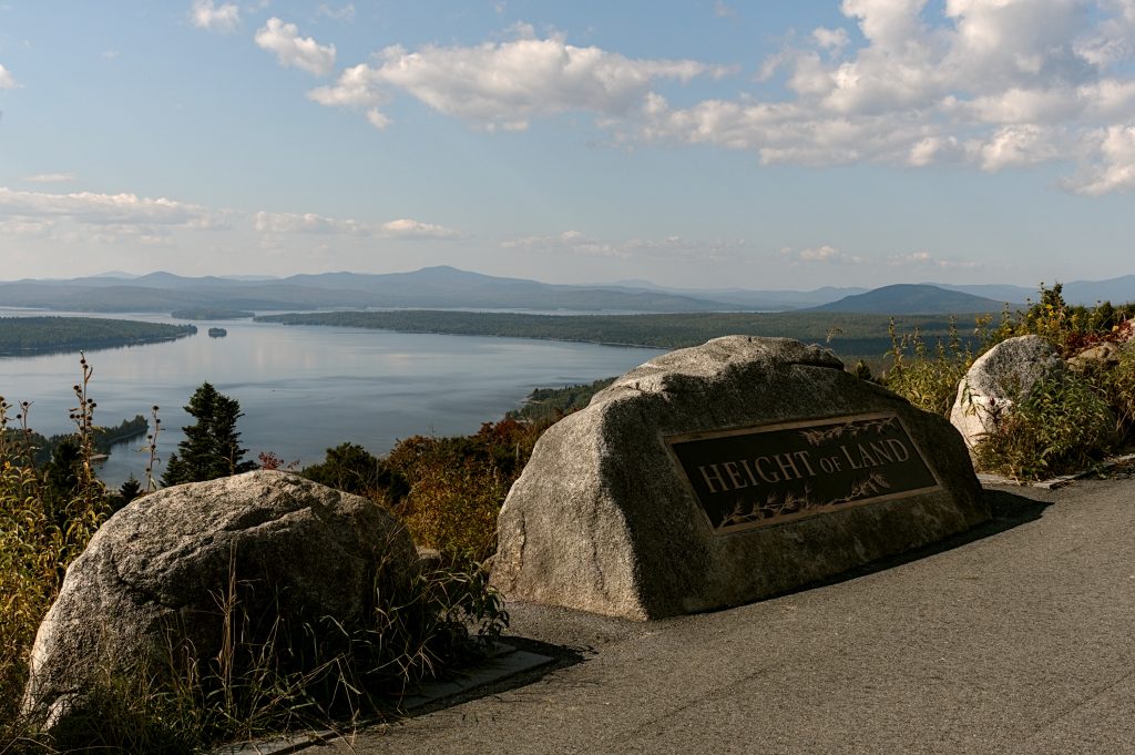
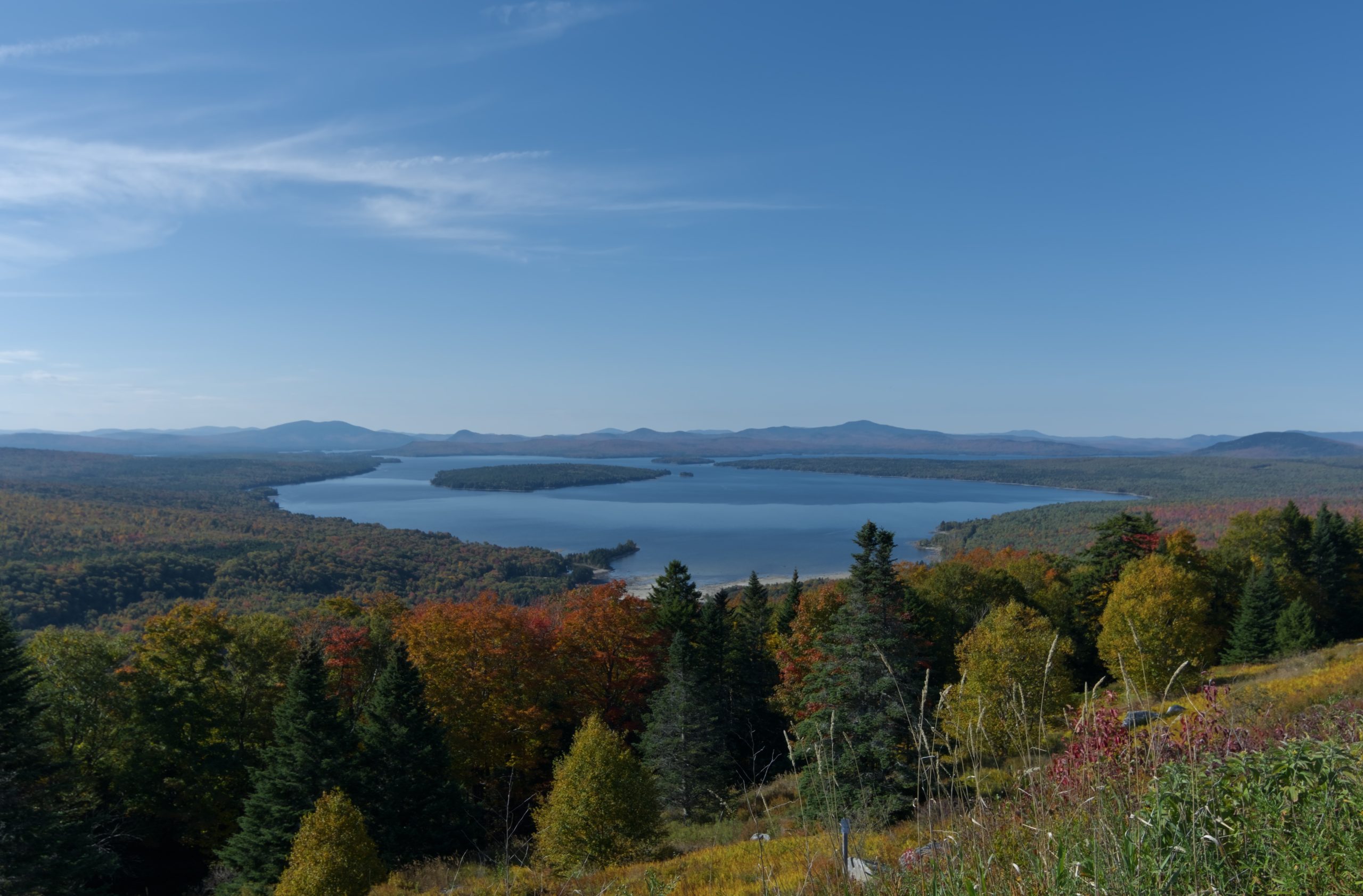
Height of Land is a roadside overlook on Route 17 in Township D, part of the Rangeley Lakes National Scenic Byway. From the overlook, Mooselookmeguntic Lake spreads out below, with the Richardson Lakes and mountains beyond.
The minute I saw it, the drive was worth it.
There’s no hike or climb involved. You pull into the paved parking lot, get out, walk a short distance toward the overlook, and Western Maine is sitting there waiting for you.
My hip appreciates this arrangement.
Unfortunately, so does everybody else.
Height of Land isn’t exactly a secret, especially during fall foliage season. Cars were constantly pulling in while we were there, and the overlook was busy enough that finding a clean place to photograph without somebody wandering into the frame took a little patience.
My original description of the situation was considerably less diplomatic: damn people everywhere.
Still, it’s hard to complain too much when you’re looking across Mooselookmeguntic Lake surrounded by peak fall color. I photographed pretty much everything I could. Lake, mountains, trees, more lake, more mountains, probably more trees.
Looking back at those photographs almost a year later, that’s the part I’d change. I’d slow down.
A landscape that big makes you want to photograph all of it. You see miles of mountains, water and fall foliage and immediately start trying to cram Western Maine into one rectangle. Now I’d spend more time looking for photographs inside the larger view. Layers of ridges. Islands. Patches of color. Something in the foreground that gives all that distance somewhere to begin.
I’d also like to come back much later in the day. The overlook faces west, and my previous visits have mostly shown me Height of Land when the light was convenient.
I’d like to see what happens when the light gets interesting.
Explorer’s Notes: Height of Land
📍 Location: Route 17, Township D, along the Rangeley Lakes National Scenic Byway
🚙 Getting There: Directly off Route 17. There’s a large paved parking area and essentially no walk to reach the main overlook.
⏱ Time to Explore: About 15 to 30 minutes for most people. Photographers could easily stay longer.
📸 Photography: The huge landscape is the obvious photograph, but don’t automatically try to fit everything into the frame. Look for smaller compositions within the view.
💡 Good to Know: Autumn can get crowded. If you’re hoping for a quiet little overlook in the mountains, this probably isn’t it.
Kevin’s Take: Almost no effort for a massive Western Maine view. Stop.
Stop 2: Quill Hill
Quill Hill was the one I hadn’t seen before, and getting there felt a little more adventurous.
You turn onto Oddy’s Road off Route 16 in Dallas Plantation and follow a dirt road roughly four miles to the summit. During our visit the road was dry and dusty, with some washboard sections. Nothing terrible, but enough that somewhere along the way I started wondering whether I should have brought a bigger vehicle.
Then we got to the top and found normal cars everywhere. Apparently the Jeep and I had survived another wilderness expedition that somebody else had completed in a sedan.
Humbling.
That wasn’t really my first reaction when we reached the summit, though.
My first reaction was, look at all the people.
Apparently half of Maine had also noticed that the foliage was near peak. The summit was busy, especially around the upper area and picnic tables, and finding a little space took some work.
Then I looked past them.

Damn.
That’s the part I remember.
Quill Hill gives you enormous panoramic views across Western Maine, with mountains and forest seemingly continuing in every direction. During fall foliage season, all of it becomes layer after layer of color.
It’s difficult to describe without drifting into tourism-brochure territory. It’s just big. And peaceful, or at least it would have been peaceful if several hundred of my closest friends hadn’t shown up.
The photography problem at Quill Hill is almost the opposite of not having enough to work with. There’s too much. Point the camera one way and there are mountains. Turn around and there are more mountains. Walk a little farther and you’ve got a completely different view.

I wanted to capture the complete 360-degree experience, but I never really managed it. Looking back, I think I was trying too hard to photograph the view instead of finding photographs inside the view.
If I returned now with the D810 and the 24-120mm, I’d work it much more deliberately. I’d look for overlapping ridges, tighter sections of foliage, or a foreground tree or rock that gives all that enormous space an anchor.
I’d still make the panorama. I’m not completely insane.
But I wouldn’t let the panorama be the only thing I saw.
You also don’t need to hike to enjoy the primary views. The summit is accessible from the parking area, with additional walking available if you want to explore farther.
I’d give Quill Hill at least half an hour. An hour would be better.
Bring lunch. Find a place to sit. Once the camera is put away, Quill Hill seems like exactly the sort of place where doing absolutely nothing for a while would be time well spent.
Preferably on a day when everybody else has decided to do absolutely nothing somewhere else.
Explorer’s Notes: Quill Hill
📍 Location: Dallas Plantation, in the Rangeley area
🚙 Getting There: Turn onto Oddy’s Road from Route 16 and follow the dirt road roughly four miles to the summit.
🛞 Road Reality: It was dry, dusty and washboarded in spots during our visit. Go slowly, especially where traffic narrows things down.
⏱ Time to Explore: Plan on 30 to 60 minutes. Longer if you’re bringing lunch or really working the landscape.
🥾 Trail: Hiking isn’t necessary for the main summit views.
📸 Photography: Walk around before committing to a composition. The huge view makes it easy to photograph everything without really photographing anything.
💡 Good to Know: Quill Hill is privately owned and maintained, and access is gated. Check current access before making the drive.
Kevin’s Take: You can get a hell of a view without climbing a mountain first. My hip approves.
Stop 3: Flagstaff Village and Bigelow Mountain View
This one wasn’t on the original itinerary.
We’d done Height of Land. We’d done Quill Hill. We were already a ridiculous distance from home, so a sensible person might have started driving back toward Midcoast Maine.
I opened Google Maps.
I found another scenic overlook not far away on Route 27.
Well, hell. We’re already here.
Flagstaff Village and Bigelow Mountain View is a small roadside overlook near Eustis and Stratton, looking across Flagstaff Lake toward the Bigelow Range. There really isn’t much to it, which is part of what made it such a surprise.
It ended up being my favorite stop of the day.
You can see the lake and mountains from the road. We pulled into the small parking area, Retta took the opportunity to stretch her legs, and I saw the tall grass.
CAMERA TIME.
Compared with Quill Hill, the place was almost empty. There was only one other car in the parking lot while we were there, with occasional traffic passing on Route 27. After spending part of the day trying to photograph around people, the quiet was nice.
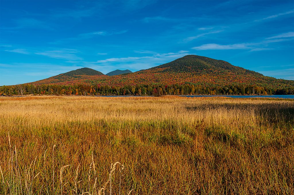
What really grabbed me, though, was the composition. Tall grass in the foreground, Flagstaff Lake through the middle, peak autumn color and the Bigelow Range rising behind it.
Instead of another enormous mountain scene floating somewhere in the distance, the grass gave the photograph a place to start. It added depth and made the autumn colors in the mountains stand out even more.
That’s something I understand better now than I did when I made the photograph. Sometimes the difference between photographing a beautiful view and making a photograph out of it is simply giving the eye somewhere to enter.
I crossed Route 27 and tried working the other side as well. There was more of the lake to work with, but the sun had other plans. The glare was brutal at that time of day, so that composition wasn’t going to happen.
That’s one reason this little stop has so much return potential for me. Give me dramatic clouds over the Bigelows, sunrise or sunset light, fog, or peak foliage under a better sky, and I’d happily pull over again.
The overlook also has interpretive signs about the Bigelow Range and Flagstaff Village, one of the communities affected by the creation of Flagstaff Lake.
But you don’t need a history lesson or an itinerary to appreciate this place. Sometimes you just need fifteen minutes. Get out, stretch your legs, look across the lake, and get back in the car.
Unless you brought a camera.
Then fifteen minutes becomes negotiable.
Explorer’s Notes: Flagstaff Village and Bigelow Mountain View
📍 Location: Route 27 near Eustis and Stratton
🚙 Getting There: Direct roadside pull-off with a small parking lot. No hike involved.
⏱ Time to Explore: About 15 minutes for a quick stop, longer if the light is doing something interesting.
📸 Photography: The tall grass gives you a natural foreground with Flagstaff Lake and the Bigelow Range behind it. Don’t automatically stay beside the parking area. There are photographic possibilities on both sides of Route 27.
💡 Good to Know: There’s not much here in the traditional sense. It’s a scenic pull-off, not a half-day destination.
Kevin’s Take: One of those rare photography locations where my hip doesn’t have to earn the view first.
Three Stops, Almost No Hiking
One thing I didn’t really think about during the trip stands out looking back at it now: none of these places makes you work very hard for the view.
Height of Land is essentially beside the parking lot. Quill Hill requires the dirt-road drive, but once you’re at the summit, the landscape is right there. Flagstaff Village and Bigelow Mountain View is a roadside pull-off.
That’s useful if you’re planning a long fall drive through Western Maine and don’t necessarily want every stop to become a two-hour hike. You can break up the drive, get out of the car, photograph something ridiculous, stretch your legs and keep moving.
Which is pretty much what we did.
The Moose Incident
There was one other memorable moment from all that driving.
I’d been hoping to see a moose. This was Western Maine, after all. We’d spent the day driving through what looked to me like perfectly respectable moose country, and I kept watching for one.
Nothing.
Then, somewhere along the drive, Retta suddenly said, “Moose.”
Well, now she had my attention.
I’d been waiting for this all day, so I started looking. Left side of the road, right side, into the woods. Where’s the moose?
“Moose,” she said again, only louder.
Now I’m looking even harder because apparently there’s a moose somewhere nearby and I am somehow the only person in the Jeep who can’t find the damn thing.
“MOOSE!”
Then she grabbed my arm.
I looked straight ahead and there was a freaking deer standing in the road.
I hit the brakes hard. We stopped, the deer remained a deer, and the Jeep remained a Jeep.
Once my heart returned to somewhere near its normal location, I learned something important about my co-pilot.
Apparently, in an emergency, “moose” means “deer directly in front of the Jeep.”
This seems like something that should have been covered during orientation.
If I Did the Drive Again
I’d visit all three again, but I’d change the trip.
I’d add more stops. Coos Canyon would be an obvious addition, and I’d like to work the Wire Bridge in New Portland into a future Western Maine trip too.
I’d take the D810 and the Nikon 24-120mm f/4. I’d bring the tripod. Most importantly, I’d slow down.
That’s probably the biggest photography lesson I took from the trip. At the time, I saw these huge landscapes and wanted to photograph everything. Now I’d spend more time asking what inside that landscape actually caught my attention.
Maybe it’s the whole view. Maybe it’s one mountain ridge, the way the grass leads toward the lake, or one patch of sunlight hitting autumn color ten miles away. I’d give myself enough time to figure that out instead of immediately pointing the camera at the biggest thing in front of me.
I’d also pack more food. There were not enough snacks and there were definitely not enough coffee stops.
And Retta’s annual co-pilot performance review now has several areas requiring improvement. DJ performance needs work. Snack logistics were questionable. Wildlife identification during time-sensitive situations is deeply concerning.
Further training may be required.
If You Can Only Pick One
That’s harder.
Height of Land is the easiest recommendation. If you’re traveling Route 17 through Western Maine, stop. It’s one of those places where fifteen minutes gets you a view that feels much farther from the road than it actually is.
Quill Hill has the most photographic potential for me. I’d like another shot at it with the D810, more time, tighter compositions and preferably about 90 percent fewer people.
But if you’re asking which one I remember most fondly from this particular trip, it’s Flagstaff Village and Bigelow Mountain View.
That’s the surprise.
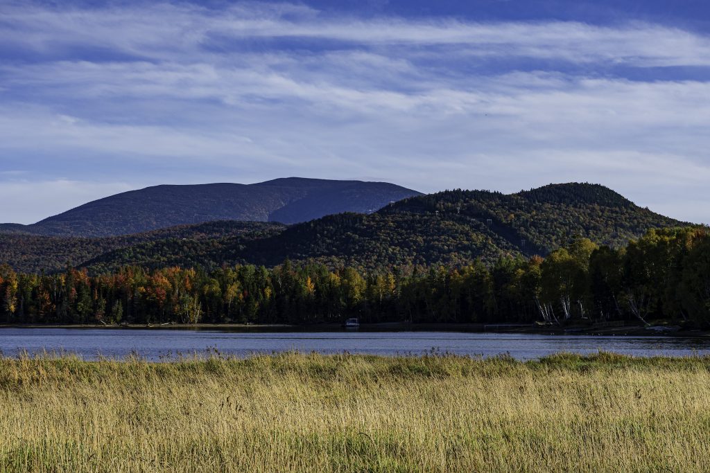
It wasn’t part of the original plan. I found it while looking for one more place to go after Quill Hill. There wasn’t much there and there weren’t many people. There was just tall grass, a lake, peak foliage and the Bigelow Range stretching across the horizon.
Sometimes the place you add because hell, we’re already here ends up being the one that sticks.
Keep Exploring
The thing I remember most about that day is the ridiculous drive. I guess the scenery wasn’t half bad either.
Next time I’d add Coos Canyon, find the Wire Bridge, give Quill Hill more time, try Height of Land near sunset and go back to Flagstaff when the sky has a little more personality.
I’d bring more snacks. More coffee. Possibly a replacement DJ.
And I’d establish a clear rule that “moose” should only be used when the animal in question is, in fact, a moose.
Because after driving all over Western Maine during peak foliage, past mountains, lakes, forests and approximately enough moose habitat to fill the entire state…
I still didn’t see a damn moose.